These functions subset a data frame by applying the expressions in ...
to determine which rows should be kept (for filter()) or dropped (for
filter_out()).
Multiple conditions can be supplied separated by a comma. These will be
combined with the & operator. To combine comma separated conditions using
| instead, wrap them in dplyr::when_any().
Both filter() and filter_out() treat NA like FALSE. This subtle
behavior can affect how you write your conditions when missing values are
involved. See dplyr::filter().
You can filter a SpatRaster by its geographic coordinates.
Use filter(.data, x > 42). The names x and y are reserved in
terra because they refer to the geographic coordinates of the
layer.
See Examples and section About layer names on as_tibble.Spat().
Usage
# S3 method for class 'SpatRaster'
filter(.data, ..., .preserve = FALSE, .keep_extent = TRUE)

# S3 method for class 'SpatVector'
filter(.data, ..., .by = NULL, .preserve = FALSE)

# S3 method for class 'SpatVector'
filter_out(.data, ..., .by = NULL, .preserve = FALSE)
Arguments
- .data
A
SpatRastercreated withterra::rast()or aSpatVectorcreated withterra::vect().- ...
<
data-masking> Expressions that return a logical value and are defined in terms of the layers/attributes in.data. If multiple expressions are included, they are combined with the&operator. Only cells/geometries for which all conditions evaluate toTRUEare kept. See Methods.- .preserve
Relevant when the
.datainput is grouped. If.preserve = FALSE(the default), the grouping structure is recalculated based on the resulting data, otherwise the grouping is kept as is.- .keep_extent
Logical. If
TRUE, keep the extent of the resultingSpatRaster. OnFALSE,terra::trim()is called so the extent may differ from the extent of the output. See alsodrop_na.SpatRaster().- .by
<
tidy-select> Optionally, a selection of columns to group by for just this operation, functioning as an alternative togroup_by(). For details and examples, see ?dplyr_by.
Methods
Implementation of the generic dplyr::filter() methods for Spat*
objects.
SpatRaster
Cells that do not meet the conditions in ... are returned as NA. On a
multi-layer SpatRaster, NA is propagated across all layers.
If .keep_extent = TRUE, the returned SpatRaster has the same CRS,
extent, resolution and number of cells as .data. If
.keep_extent = FALSE, the outer NA cells are trimmed with
terra::trim(), so the extent and number of cells may differ. The output
still has the same CRS and resolution as .data.
The x and y coordinates of the SpatRaster are also available
internally for filtering. See Examples.
See also
Other dplyr verbs that operate on rows:
arrange.SpatVector(),
distinct.SpatVector(),
rows.SpatVector,
slice.Spat
Examples
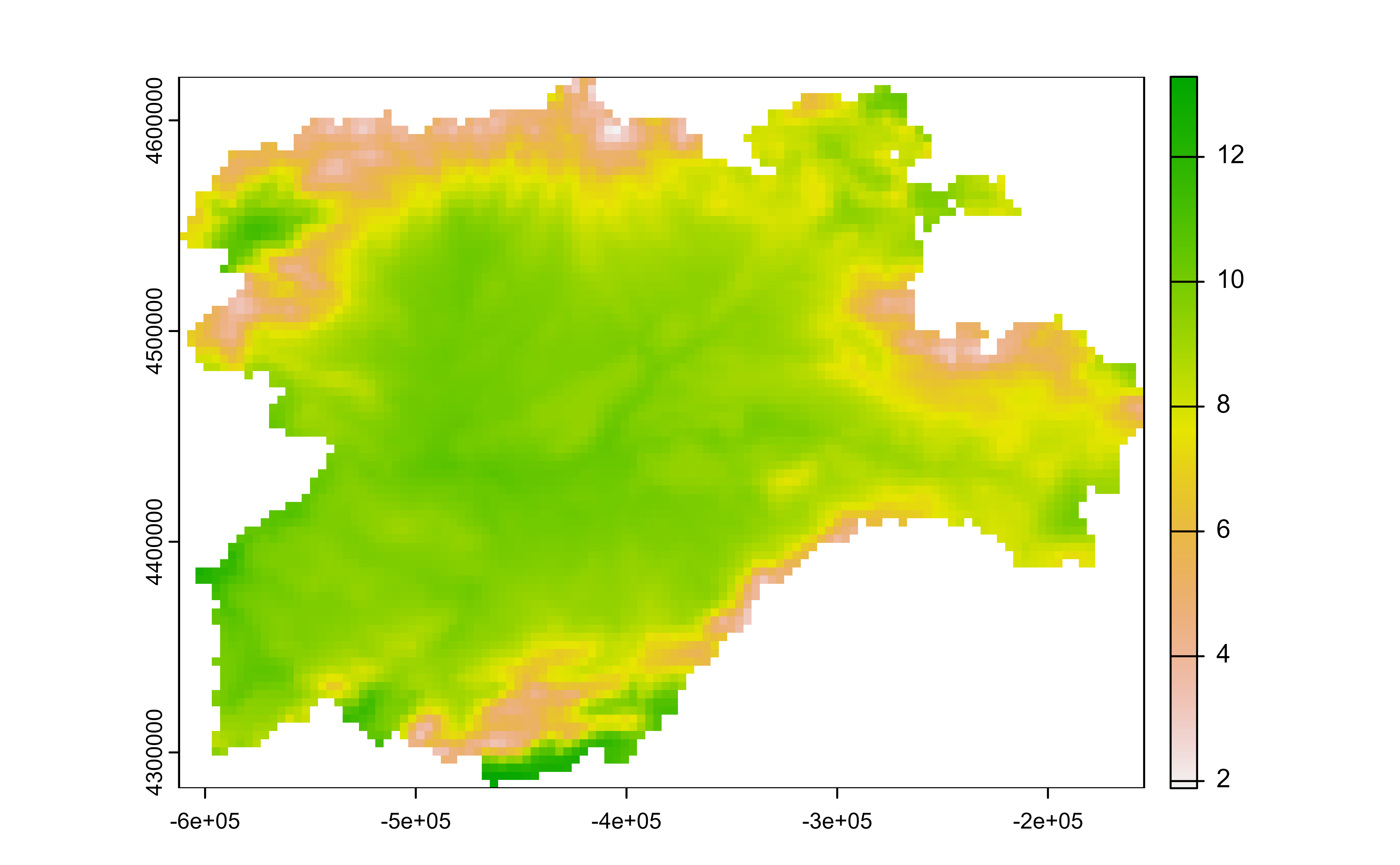
library(terra)
f <- system.file("extdata/cyl_temp.tif", package = "tidyterra")
r <- rast(f) |> select(tavg_04)
plot(r)
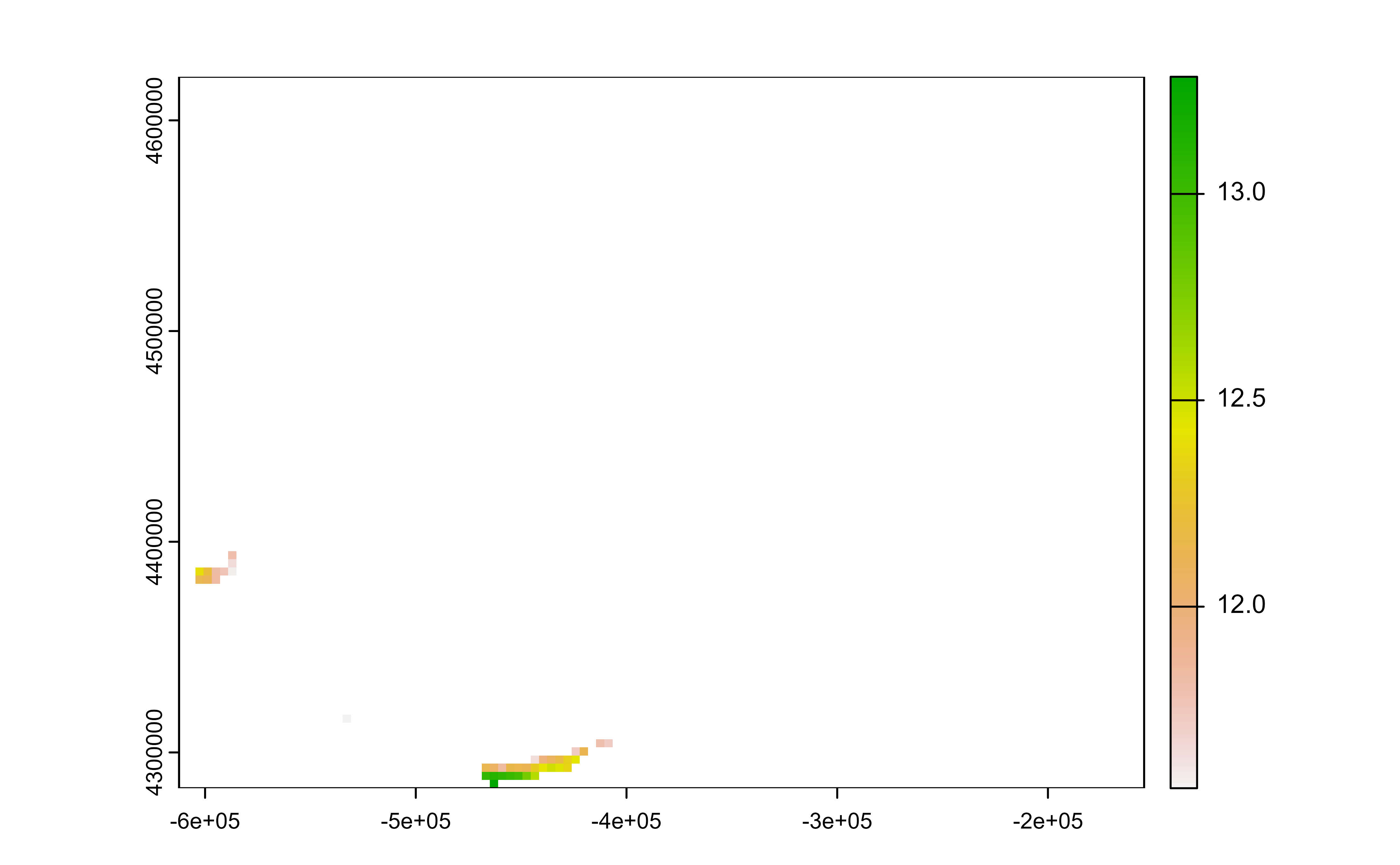
 # Filter temps
r_f <- r |> filter(tavg_04 > 11.5)
# Extent is kept
plot(r_f)
# Filter temps
r_f <- r |> filter(tavg_04 > 11.5)
# Extent is kept
plot(r_f)
 # Filter temps and extent
r_f2 <- r |> filter(tavg_04 > 11.5, .keep_extent = FALSE)
# Extent has changed
plot(r_f2)
# Filter temps and extent
r_f2 <- r |> filter(tavg_04 > 11.5, .keep_extent = FALSE)
# Extent has changed
plot(r_f2)
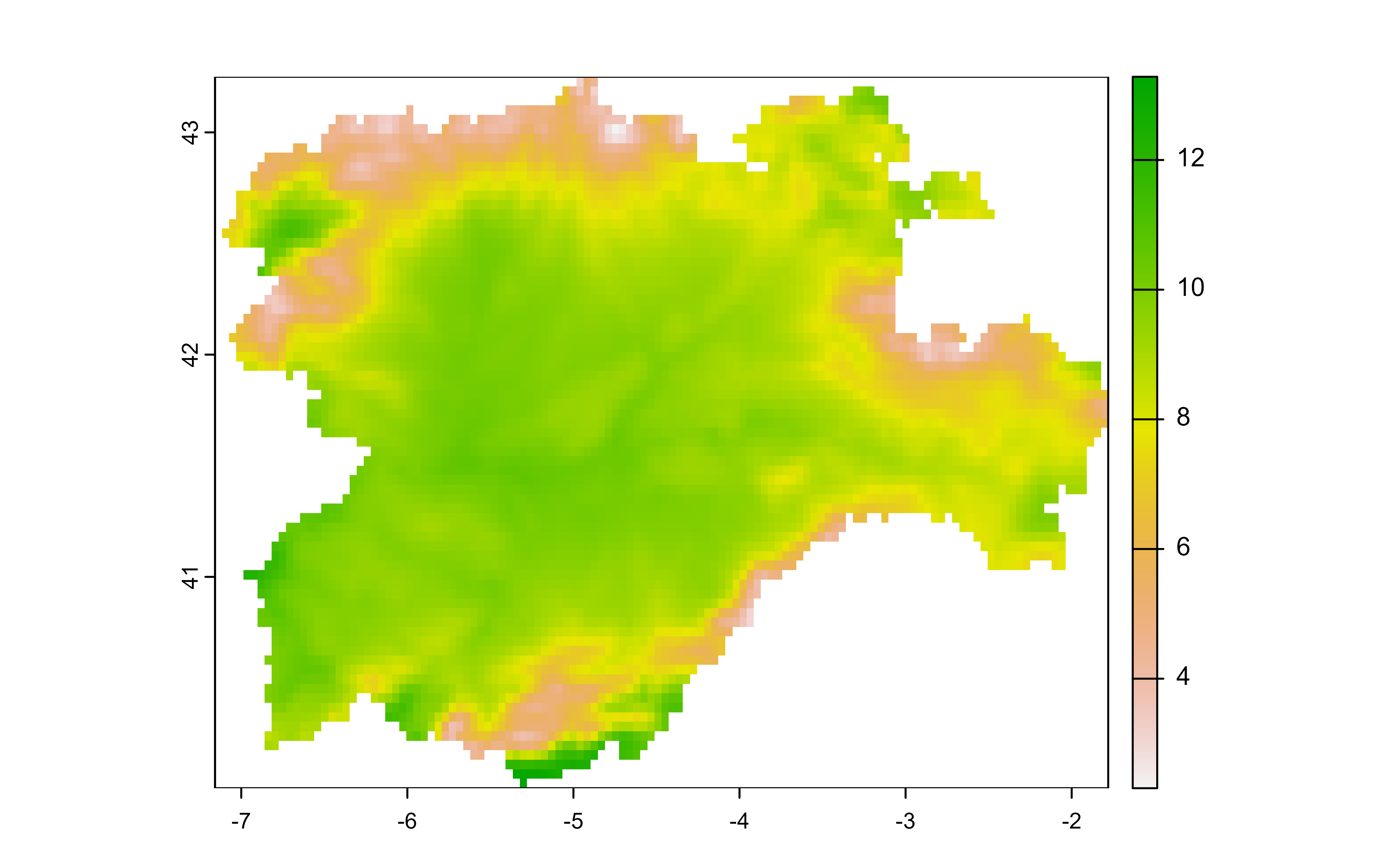
 # Filter by geographic coordinates
r2 <- project(r, "epsg:4326")
r2 |> plot()
# Filter by geographic coordinates
r2 <- project(r, "epsg:4326")
r2 |> plot()
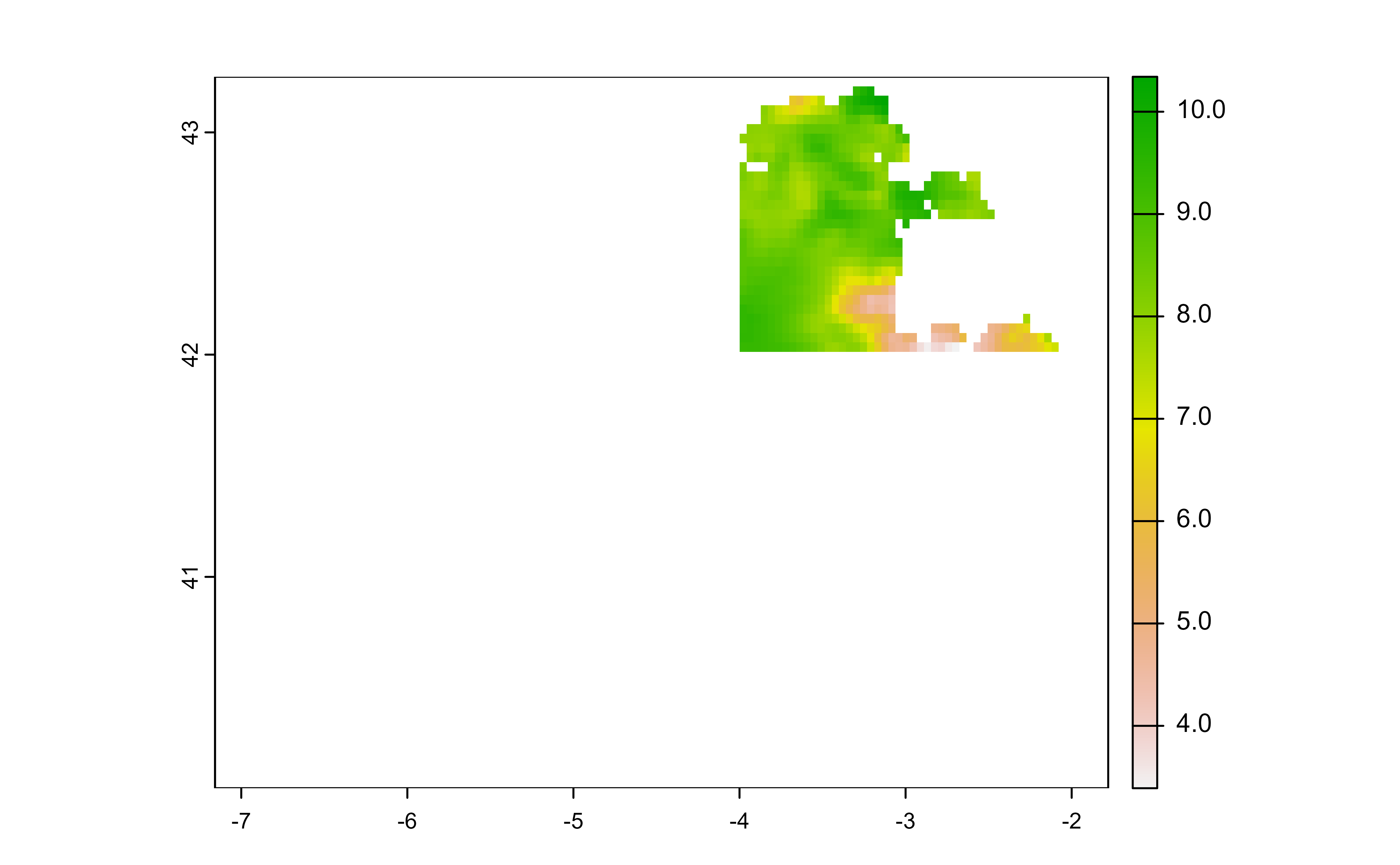
 r2 |>
filter(
x > -4,
x < -2,
y > 42
) |>
plot()
r2 |>
filter(
x > -4,
x < -2,
y > 42
) |>
plot()
 v <- terra::vect(system.file("extdata/cyl.gpkg", package = "tidyterra"))
glimpse(v)
#> # A SpatVector 9 x 3
#> # Geometry type: Polygons
#> # Projected CRS: ETRS89-extended / LAEA Europe (EPSG:3035)
#> # CRS projection units: meter <m>
#> # Extent (x / y): ([2,892,687 / 3,341,372] , [2,017,622 / 2,361,600])
#>
#> $ iso2 <chr> "ES-AV", "ES-BU", "ES-LE", "ES-P", "ES-SA", "ES-SG", "ES-SO", "ES…
#> $ cpro <chr> "05", "09", "24", "34", "37", "40", "42", "47", "49"
#> $ name <chr> "Avila", "Burgos", "Leon", "Palencia", "Salamanca", "Segovia", "S…
v |> filter(cpro < 10)
#> class : SpatVector
#> geometry : polygons
#> dimensions : 2, 3 (geometries, attributes)
#> extent : 2987054, 3296229, 2017622, 2331004 (xmin, xmax, ymin, ymax)
#> coord. ref. : ETRS89-extended / LAEA Europe (EPSG:3035)
#> names : iso2 cpro name
#> type : <chr> <chr> <chr>
#> values : ES-AV 05 Avila
#> ES-BU 09 Burgos
# Same as
v |> filter_out(cpro >= 10)
#> class : SpatVector
#> geometry : polygons
#> dimensions : 2, 3 (geometries, attributes)
#> extent : 2987054, 3296229, 2017622, 2331004 (xmin, xmax, ymin, ymax)
#> coord. ref. : ETRS89-extended / LAEA Europe (EPSG:3035)
#> names : iso2 cpro name
#> type : <chr> <chr> <chr>
#> values : ES-AV 05 Avila
#> ES-BU 09 Burgos
v <- terra::vect(system.file("extdata/cyl.gpkg", package = "tidyterra"))
glimpse(v)
#> # A SpatVector 9 x 3
#> # Geometry type: Polygons
#> # Projected CRS: ETRS89-extended / LAEA Europe (EPSG:3035)
#> # CRS projection units: meter <m>
#> # Extent (x / y): ([2,892,687 / 3,341,372] , [2,017,622 / 2,361,600])
#>
#> $ iso2 <chr> "ES-AV", "ES-BU", "ES-LE", "ES-P", "ES-SA", "ES-SG", "ES-SO", "ES…
#> $ cpro <chr> "05", "09", "24", "34", "37", "40", "42", "47", "49"
#> $ name <chr> "Avila", "Burgos", "Leon", "Palencia", "Salamanca", "Segovia", "S…
v |> filter(cpro < 10)
#> class : SpatVector
#> geometry : polygons
#> dimensions : 2, 3 (geometries, attributes)
#> extent : 2987054, 3296229, 2017622, 2331004 (xmin, xmax, ymin, ymax)
#> coord. ref. : ETRS89-extended / LAEA Europe (EPSG:3035)
#> names : iso2 cpro name
#> type : <chr> <chr> <chr>
#> values : ES-AV 05 Avila
#> ES-BU 09 Burgos
# Same as
v |> filter_out(cpro >= 10)
#> class : SpatVector
#> geometry : polygons
#> dimensions : 2, 3 (geometries, attributes)
#> extent : 2987054, 3296229, 2017622, 2331004 (xmin, xmax, ymin, ymax)
#> coord. ref. : ETRS89-extended / LAEA Europe (EPSG:3035)
#> names : iso2 cpro name
#> type : <chr> <chr> <chr>
#> values : ES-AV 05 Avila
#> ES-BU 09 Burgos