slice() methods let you index cells/rows/columns/geometries by their
(integer) locations. They allow you to select, remove or duplicate those
dimensions of a Spat* object.
If you want to slice by geographic coordinates, use filter.SpatRaster().
It includes helpers for common use cases:
slice_head()andslice_tail()select the first or last cells/geometries.slice_sample()randomly selects cells/geometries.slice_rows()andslice_cols()subset entire rows or columns of aSpatRaster.slice_colrows()subsets regions of theSpatRasterby row and column position of aSpatRaster.
You can get a skeleton of your SpatRaster with the cell, column and row
index with as_coordinates().
See Methods for details.
Usage
# S3 method for class 'SpatRaster'
slice(.data, ..., .preserve = FALSE, .keep_extent = FALSE)

# S3 method for class 'SpatVector'
slice(.data, ..., .by = NULL, .preserve = FALSE)

# S3 method for class 'SpatRaster'
slice_head(.data, ..., n, prop, .keep_extent = FALSE)

# S3 method for class 'SpatVector'
slice_head(.data, ..., n, prop, by = NULL)

# S3 method for class 'SpatRaster'
slice_tail(.data, ..., n, prop, .keep_extent = FALSE)

# S3 method for class 'SpatVector'
slice_tail(.data, ..., n, prop, by = NULL)

# S3 method for class 'SpatRaster'
slice_min(
  .data,
  order_by,
  ...,
  n,
  prop,
  with_ties = TRUE,
  .keep_extent = FALSE,
  na.rm = TRUE
)

# S3 method for class 'SpatVector'
slice_min(
  .data,
  order_by,
  ...,
  n,
  prop,
  by = NULL,
  with_ties = TRUE,
  na_rm = FALSE
)

# S3 method for class 'SpatRaster'
slice_max(
  .data,
  order_by,
  ...,
  n,
  prop,
  with_ties = TRUE,
  .keep_extent = FALSE,
  na.rm = TRUE
)

# S3 method for class 'SpatVector'
slice_max(
  .data,
  order_by,
  ...,
  n,
  prop,
  by = NULL,
  with_ties = TRUE,
  na_rm = FALSE
)

# S3 method for class 'SpatRaster'
slice_sample(
  .data,
  ...,
  n,
  prop,
  weight_by = NULL,
  replace = FALSE,
  .keep_extent = FALSE
)

# S3 method for class 'SpatVector'
slice_sample(.data, ..., n, prop, by = NULL, weight_by = NULL, replace = FALSE)

slice_rows(.data, ...)

# S3 method for class 'SpatRaster'
slice_rows(.data, ..., .keep_extent = FALSE)

slice_cols(.data, ...)

# S3 method for class 'SpatRaster'
slice_cols(.data, ..., .keep_extent = FALSE)

slice_colrows(.data, ...)

# S3 method for class 'SpatRaster'
slice_colrows(.data, ..., cols, rows, .keep_extent = FALSE, inverse = FALSE)
Arguments
- .data
A
SpatRastercreated withterra::rast()or aSpatVectorcreated withterra::vect().- ...
<
data-masking> Integer row values. Provide either positive values to keep or negative values to drop. The values provided must be either all positive or all negative. Indices beyond the number of rows in the input are silently ignored. See Methods.- .preserve
Ignored for
Spat*objects.- .keep_extent
Logical. If
TRUE, keep the extent of the resultingSpatRaster. See alsoterra::trim(),terra::extend().- .by, by
<
tidy-select> Optionally, a selection of columns to group by for just this operation, functioning as an alternative togroup_by(). For details and examples, see ?dplyr_by.- n, prop
Provide either
n, the number of rows, orprop, the proportion of rows to select. If neither are supplied,n = 1will be used. Ifnis greater than the number of rows in the group (orprop > 1), the result will be silently truncated to the group size.propwill be rounded towards zero to generate an integer number of rows.A negative value of
norpropwill be subtracted from the group size. For example,n = -2with a group of 5 rows will select 5 - 2 = 3 rows;prop = -0.25with 8 rows will select 8 * (1 - 0.25) = 6 rows.- order_by
<
data-masking> Variable or function of variables to order by. To order by multiple variables, wrap them in a data frame or tibble.- with_ties
Should ties be kept together? The default,
TRUE, may return more rows than you request. UseFALSEto ignore ties, and return the firstnrows.- na.rm
Logical. If
TRUE, remove cells withNAvalues when computingslice_min()/slice_max(). The default isTRUE.- na_rm
Should missing values in
order_bybe removed from the result? IfFALSE,NAvalues are sorted to the end (like inarrange()), so they will only be included if there are insufficient non-missing values to reachn/prop.- weight_by
<
data-masking> Sampling weights. This must evaluate to a vector of non-negative numbers the same length as the input. Weights are automatically standardised to sum to 1. See theDetailssection for more technical details regarding these weights.- replace
Should sampling be performed with (
TRUE) or without (FALSE, the default) replacement.- cols, rows
Integer column and row values of the
SpatRaster.- inverse
If
TRUE,.datais inverse-masked to the given selection. Seeterra::mask().
terra equivalent
Methods
Implementation of the generic dplyr::slice() methods for Spat*
objects.
SpatRaster
The result is a SpatRaster with the CRS and resolution of the input and
the values of the selected cells, columns or rows.
Use .keep_extent = TRUE to preserve the extent of .data on the output.
The non-selected cells have a value of NA.
SpatVector
The result is a SpatVector where the attributes of the selected
geometries are preserved. If .data is a
grouped SpatVector, the operation will be
performed on each group, so that (e.g.) slice_head(df, n = 5) will select
the first five rows in each group.
See also
dplyr::slice(), terra::spatSample(), as_coordinates(),
filter.SpatRaster().
Other dplyr verbs that operate on rows:
arrange.SpatVector(),
distinct.SpatVector(),
filter.Spat,
rows.SpatVector
Examples
library(terra)
f <- system.file("extdata/cyl_temp.tif", package = "tidyterra")
r <- rast(f)
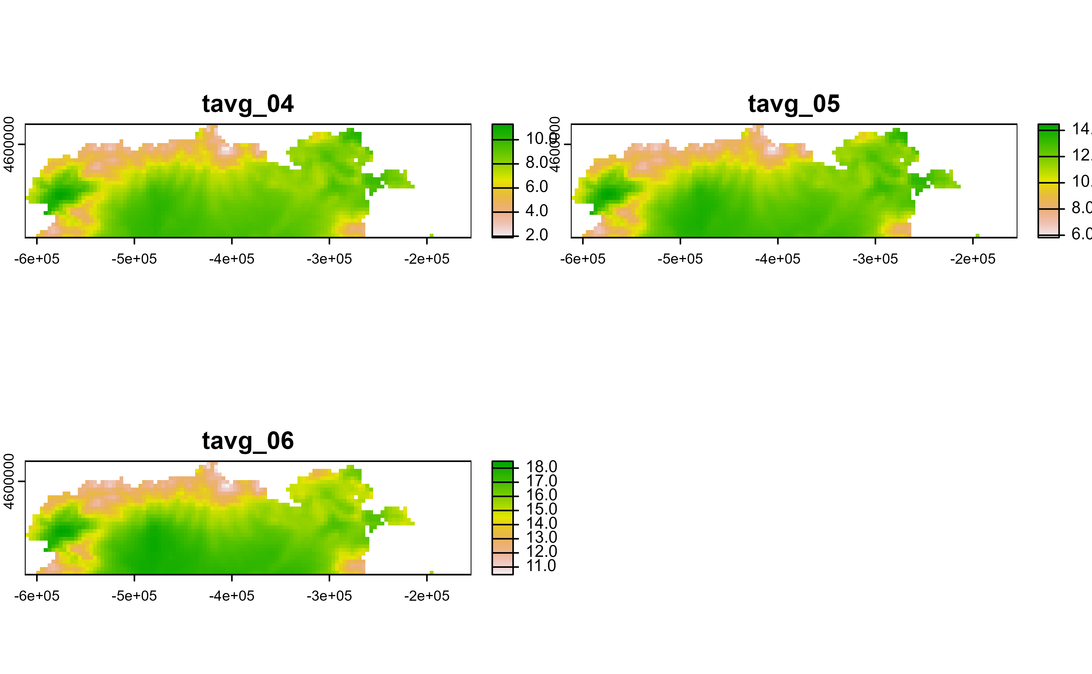
# Slice first 100 cells
r |>
slice(1:100) |>
plot()
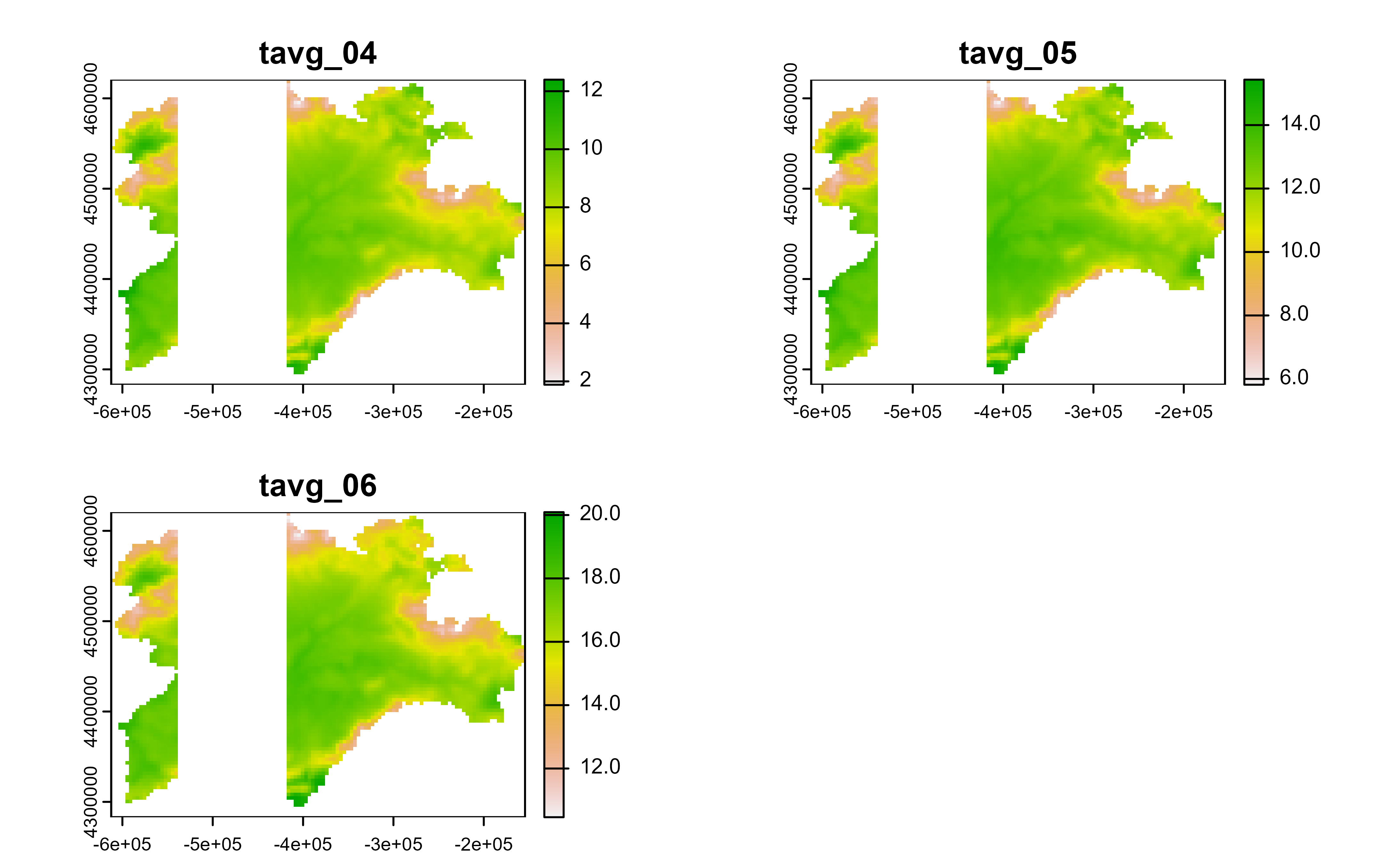
 # Rows
r |>
slice_rows(1:30) |>
plot()
# Rows
r |>
slice_rows(1:30) |>
plot()
 # Cols
r |>
slice_cols(-(20:50)) |>
plot()
# Cols
r |>
slice_cols(-(20:50)) |>
plot()
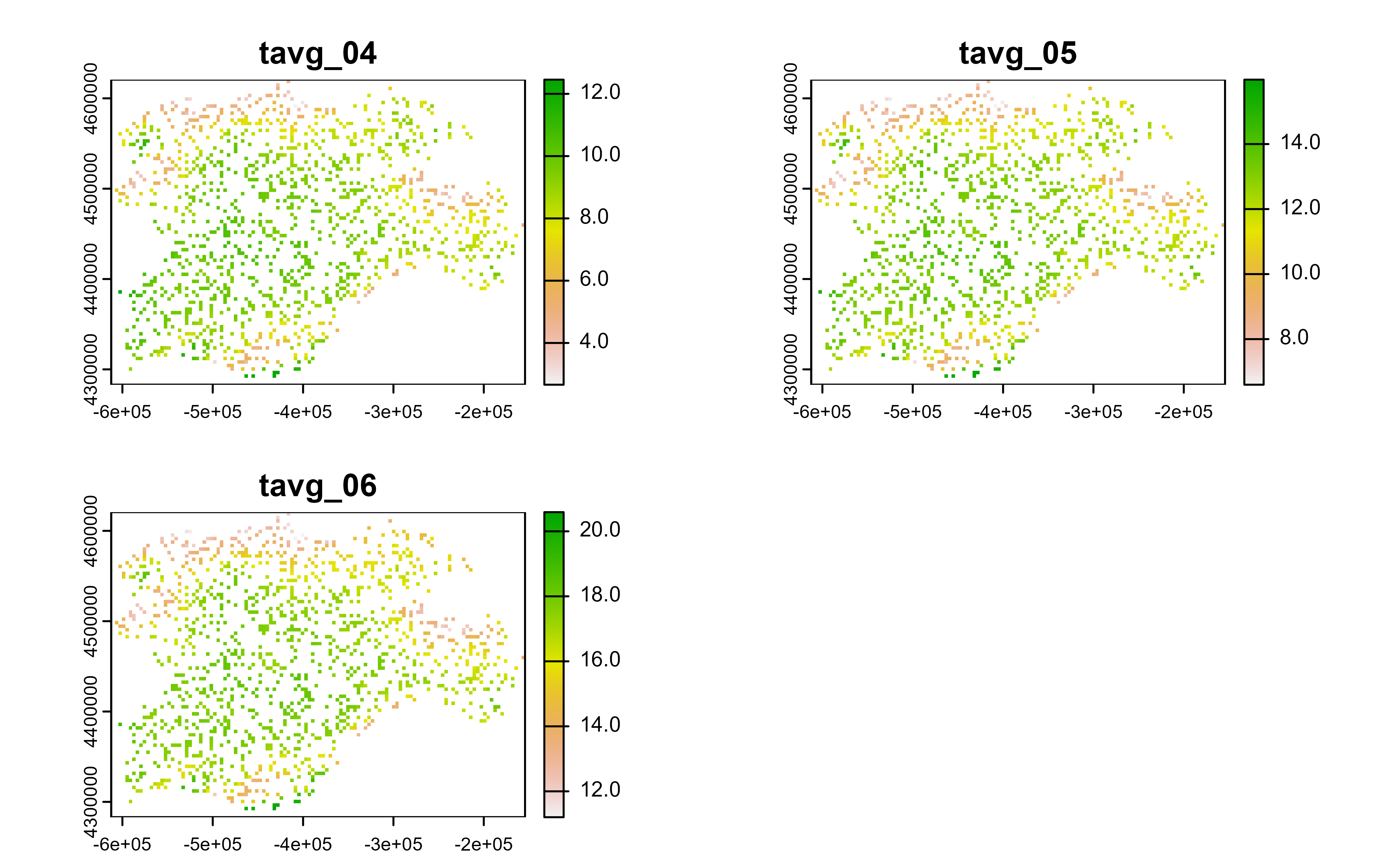
 # Spatial sample
r |>
slice_sample(prop = 0.2) |>
plot()
# Spatial sample
r |>
slice_sample(prop = 0.2) |>
plot()
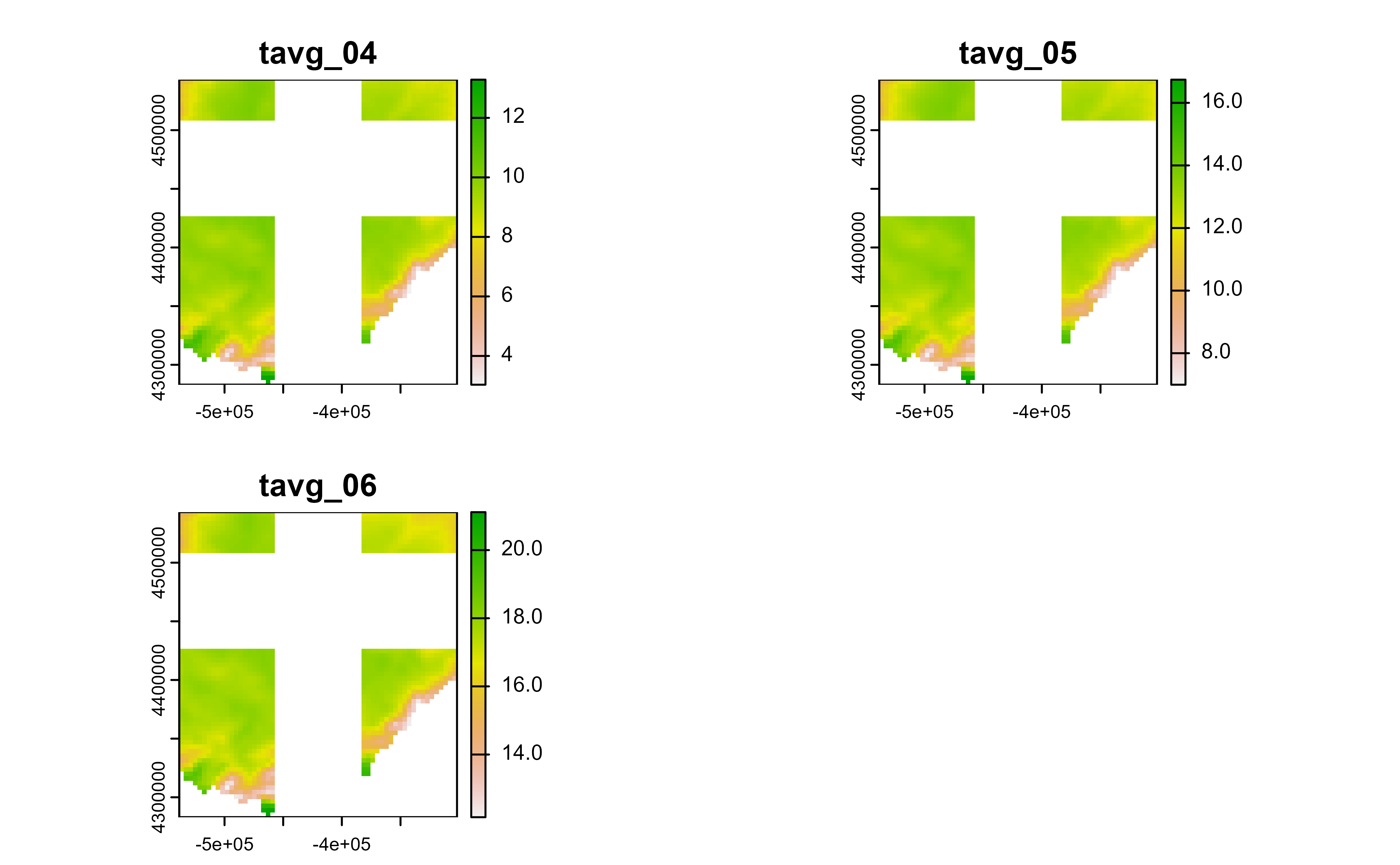
 # Slice regions
r |>
slice_colrows(
cols = c(20:40, 60:80),
rows = -c(1:20, 30:50)
) |>
plot()
# Slice regions
r |>
slice_colrows(
cols = c(20:40, 60:80),
rows = -c(1:20, 30:50)
) |>
plot()
 # Group-wise operation with SpatVector objects
v <- terra::vect(system.file("ex/lux.shp", package = "terra"))
# \donttest{
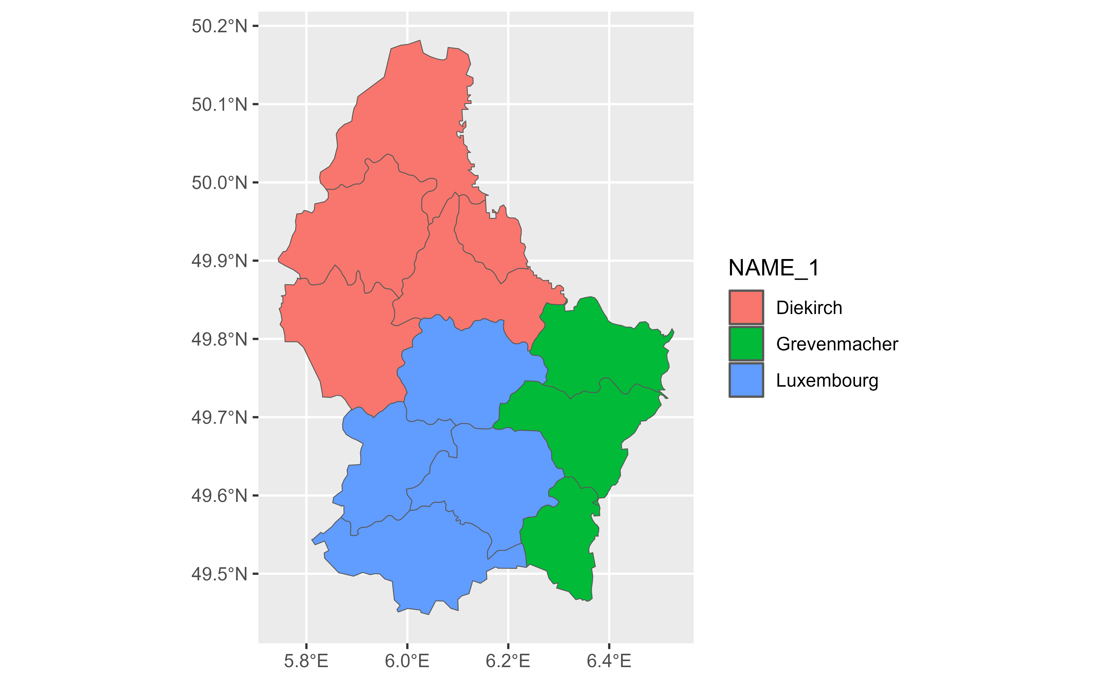
glimpse(v) |> autoplot(aes(fill = NAME_1))
#> # A SpatVector 12 x 6
#> # Geometry type: Polygons
#> # Geodetic CRS: lon/lat WGS 84 (EPSG:4326)
#> # Extent (x / y): ([5° 44' 38.9" E / 6° 31' 41.71" E] , [49° 26' 52.11" N / 50° 10' 53.84" N])
#>
#> $ ID_1 <dbl> 1, 1, 1, 1, 1, 2, 2, 2, 3, 3, 3, 3
#> $ NAME_1 <chr> "Diekirch", "Diekirch", "Diekirch", "Diekirch", "Diekirch", "Gr…
#> $ ID_2 <dbl> 1, 2, 3, 4, 5, 6, 7, 12, 8, 9, 10, 11
#> $ NAME_2 <chr> "Clervaux", "Diekirch", "Redange", "Vianden", "Wiltz", "Echtern…
#> $ AREA <dbl> 312, 218, 259, 76, 263, 188, 129, 210, 185, 251, 237, 233
#> $ POP <dbl> 18081, 32543, 18664, 5163, 16735, 18899, 22366, 29828, 48187, 1…
# Group-wise operation with SpatVector objects
v <- terra::vect(system.file("ex/lux.shp", package = "terra"))
# \donttest{
glimpse(v) |> autoplot(aes(fill = NAME_1))
#> # A SpatVector 12 x 6
#> # Geometry type: Polygons
#> # Geodetic CRS: lon/lat WGS 84 (EPSG:4326)
#> # Extent (x / y): ([5° 44' 38.9" E / 6° 31' 41.71" E] , [49° 26' 52.11" N / 50° 10' 53.84" N])
#>
#> $ ID_1 <dbl> 1, 1, 1, 1, 1, 2, 2, 2, 3, 3, 3, 3
#> $ NAME_1 <chr> "Diekirch", "Diekirch", "Diekirch", "Diekirch", "Diekirch", "Gr…
#> $ ID_2 <dbl> 1, 2, 3, 4, 5, 6, 7, 12, 8, 9, 10, 11
#> $ NAME_2 <chr> "Clervaux", "Diekirch", "Redange", "Vianden", "Wiltz", "Echtern…
#> $ AREA <dbl> 312, 218, 259, 76, 263, 188, 129, 210, 185, 251, 237, 233
#> $ POP <dbl> 18081, 32543, 18664, 5163, 16735, 18899, 22366, 29828, 48187, 1…
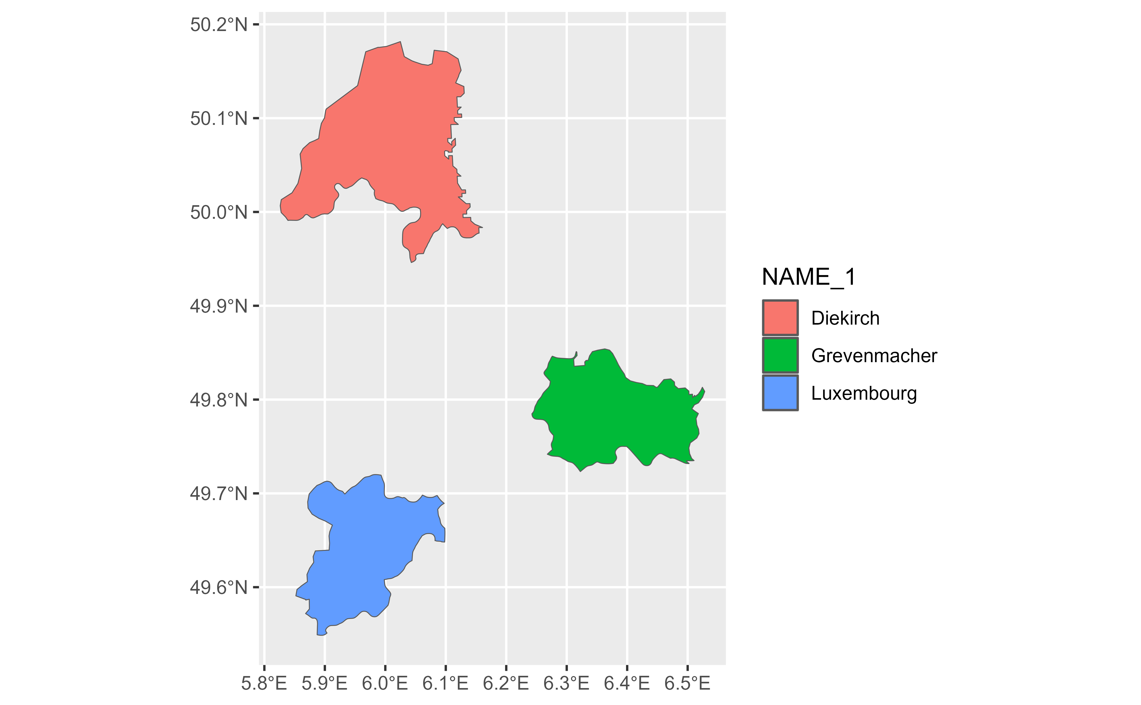
 gv <- v |> group_by(NAME_1)
# All slice helpers operate per group, silently truncating to the group
# size.
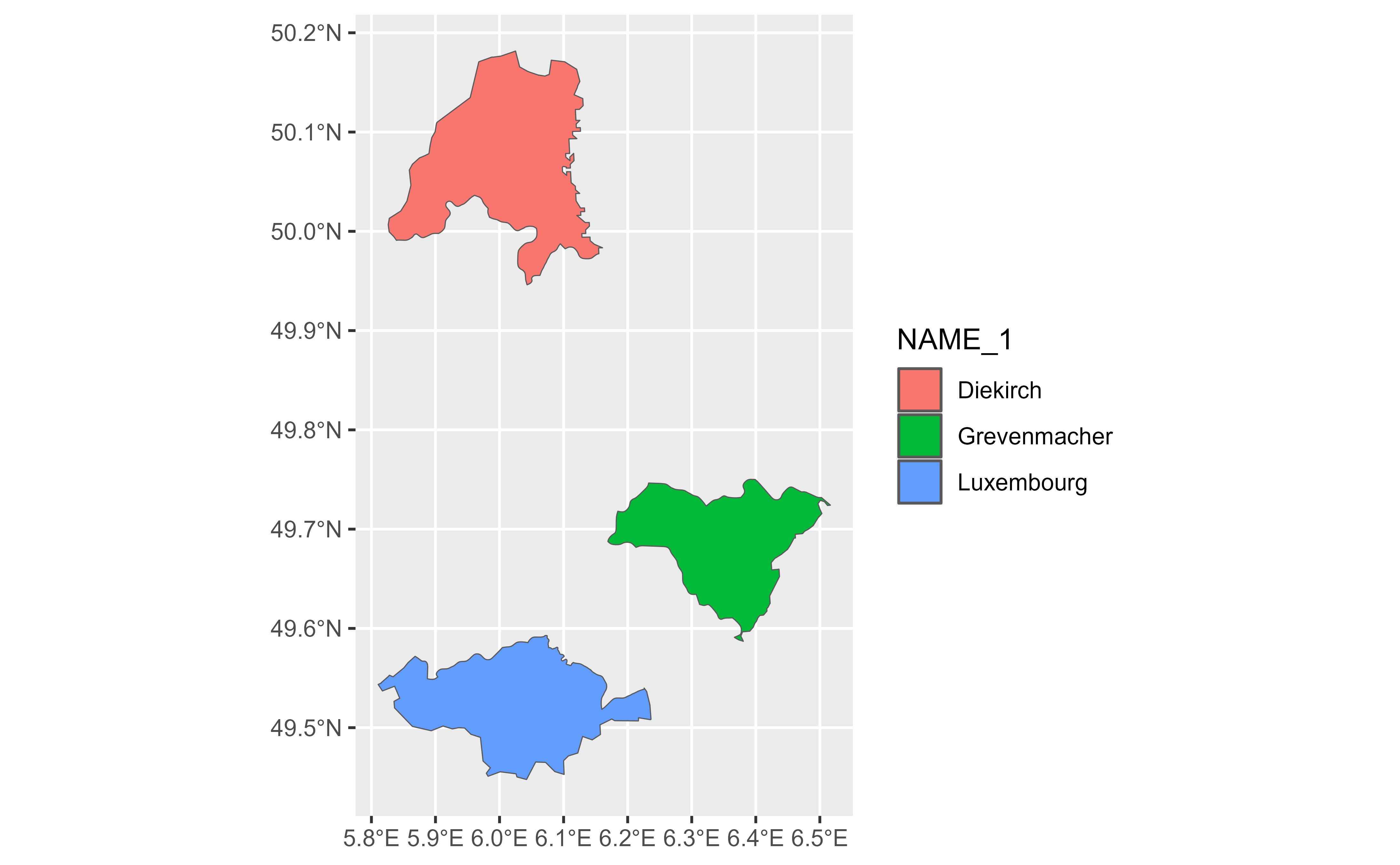
gv |>
slice_head(n = 1) |>
glimpse() |>
autoplot(aes(fill = NAME_1))
#> # A SpatVector 3 x 6
#> # Geometry type: Polygons
#> # Geodetic CRS: lon/lat WGS 84 (EPSG:4326)
#> # Extent (x / y): ([5° 49' 34.44" E / 6° 31' 41.71" E] , [49° 32' 55.33" N / 50° 10' 53.84" N])
#>
#> Groups: NAME_1 [3]
#> $ ID_1 <dbl> 1, 2, 3
#> $ NAME_1 <chr> "Diekirch", "Grevenmacher", "Luxembourg"
#> $ ID_2 <dbl> 1, 6, 8
#> $ NAME_2 <chr> "Clervaux", "Echternach", "Capellen"
#> $ AREA <dbl> 312, 188, 185
#> $ POP <dbl> 18081, 18899, 48187
gv <- v |> group_by(NAME_1)
# All slice helpers operate per group, silently truncating to the group
# size.
gv |>
slice_head(n = 1) |>
glimpse() |>
autoplot(aes(fill = NAME_1))
#> # A SpatVector 3 x 6
#> # Geometry type: Polygons
#> # Geodetic CRS: lon/lat WGS 84 (EPSG:4326)
#> # Extent (x / y): ([5° 49' 34.44" E / 6° 31' 41.71" E] , [49° 32' 55.33" N / 50° 10' 53.84" N])
#>
#> Groups: NAME_1 [3]
#> $ ID_1 <dbl> 1, 2, 3
#> $ NAME_1 <chr> "Diekirch", "Grevenmacher", "Luxembourg"
#> $ ID_2 <dbl> 1, 6, 8
#> $ NAME_2 <chr> "Clervaux", "Echternach", "Capellen"
#> $ AREA <dbl> 312, 188, 185
#> $ POP <dbl> 18081, 18899, 48187
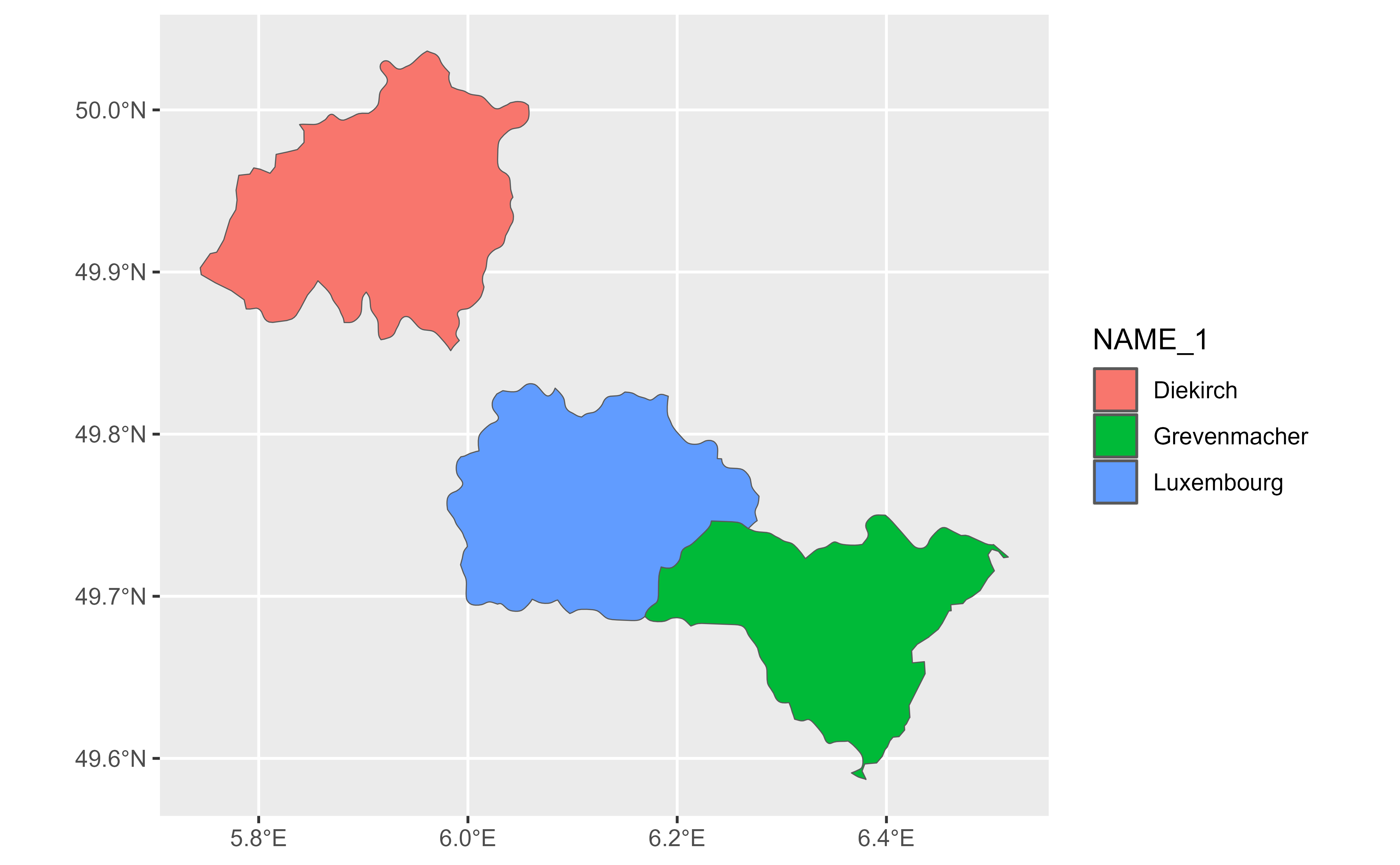
 gv |>
slice_tail(n = 1) |>
glimpse() |>
autoplot(aes(fill = NAME_1))
#> # A SpatVector 3 x 6
#> # Geometry type: Polygons
#> # Geodetic CRS: lon/lat WGS 84 (EPSG:4326)
#> # Extent (x / y): ([5° 44' 38.9" E / 6° 30' 59.35" E] , [49° 35' 13.15" N / 50° 2' 10.76" N])
#>
#> Groups: NAME_1 [3]
#> $ ID_1 <dbl> 1, 2, 3
#> $ NAME_1 <chr> "Diekirch", "Grevenmacher", "Luxembourg"
#> $ ID_2 <dbl> 5, 12, 11
#> $ NAME_2 <chr> "Wiltz", "Grevenmacher", "Mersch"
#> $ AREA <dbl> 263, 210, 233
#> $ POP <dbl> 16735, 29828, 32112
gv |>
slice_tail(n = 1) |>
glimpse() |>
autoplot(aes(fill = NAME_1))
#> # A SpatVector 3 x 6
#> # Geometry type: Polygons
#> # Geodetic CRS: lon/lat WGS 84 (EPSG:4326)
#> # Extent (x / y): ([5° 44' 38.9" E / 6° 30' 59.35" E] , [49° 35' 13.15" N / 50° 2' 10.76" N])
#>
#> Groups: NAME_1 [3]
#> $ ID_1 <dbl> 1, 2, 3
#> $ NAME_1 <chr> "Diekirch", "Grevenmacher", "Luxembourg"
#> $ ID_2 <dbl> 5, 12, 11
#> $ NAME_2 <chr> "Wiltz", "Grevenmacher", "Mersch"
#> $ AREA <dbl> 263, 210, 233
#> $ POP <dbl> 16735, 29828, 32112
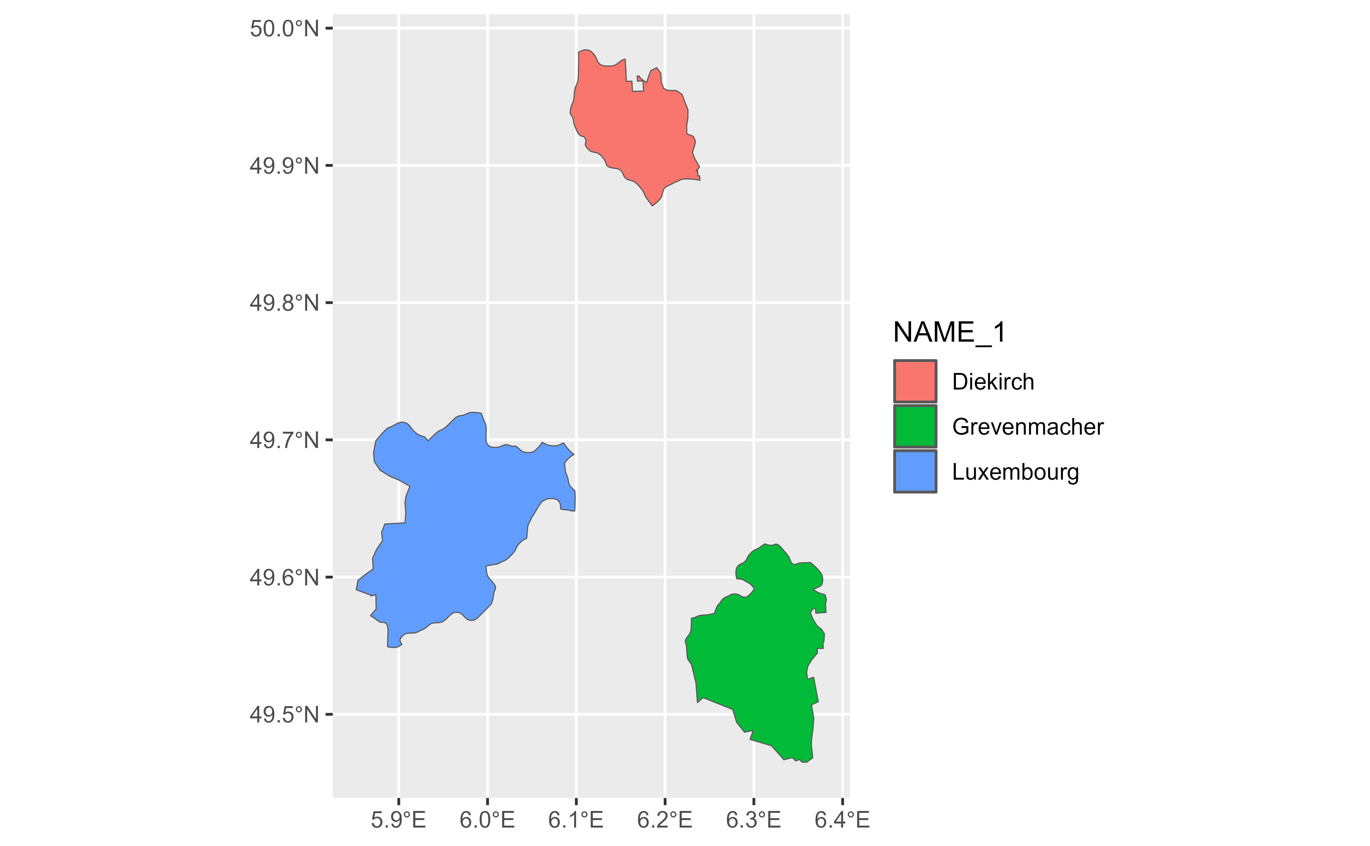
 gv |>
slice_min(AREA, n = 1) |>
glimpse() |>
autoplot(aes(fill = NAME_1))
#> # A SpatVector 3 x 6
#> # Geometry type: Polygons
#> # Geodetic CRS: lon/lat WGS 84 (EPSG:4326)
#> # Extent (x / y): ([5° 51' 7.49" E / 6° 22' 54.12" E] , [49° 27' 53.95" N / 49° 59' 2.98" N])
#>
#> Groups: NAME_1 [3]
#> $ ID_1 <dbl> 1, 2, 3
#> $ NAME_1 <chr> "Diekirch", "Grevenmacher", "Luxembourg"
#> $ ID_2 <dbl> 4, 7, 8
#> $ NAME_2 <chr> "Vianden", "Remich", "Capellen"
#> $ AREA <dbl> 76, 129, 185
#> $ POP <dbl> 5163, 22366, 48187
gv |>
slice_min(AREA, n = 1) |>
glimpse() |>
autoplot(aes(fill = NAME_1))
#> # A SpatVector 3 x 6
#> # Geometry type: Polygons
#> # Geodetic CRS: lon/lat WGS 84 (EPSG:4326)
#> # Extent (x / y): ([5° 51' 7.49" E / 6° 22' 54.12" E] , [49° 27' 53.95" N / 49° 59' 2.98" N])
#>
#> Groups: NAME_1 [3]
#> $ ID_1 <dbl> 1, 2, 3
#> $ NAME_1 <chr> "Diekirch", "Grevenmacher", "Luxembourg"
#> $ ID_2 <dbl> 4, 7, 8
#> $ NAME_2 <chr> "Vianden", "Remich", "Capellen"
#> $ AREA <dbl> 76, 129, 185
#> $ POP <dbl> 5163, 22366, 48187
 gv |>
slice_max(AREA, n = 1) |>
glimpse() |>
autoplot(aes(fill = NAME_1))
#> # A SpatVector 3 x 6
#> # Geometry type: Polygons
#> # Geodetic CRS: lon/lat WGS 84 (EPSG:4326)
#> # Extent (x / y): ([5° 48' 37.74" E / 6° 30' 59.35" E] , [49° 26' 52.11" N / 50° 10' 53.84" N])
#>
#> Groups: NAME_1 [3]
#> $ ID_1 <dbl> 1, 2, 3
#> $ NAME_1 <chr> "Diekirch", "Grevenmacher", "Luxembourg"
#> $ ID_2 <dbl> 1, 12, 9
#> $ NAME_2 <chr> "Clervaux", "Grevenmacher", "Esch-sur-Alzette"
#> $ AREA <dbl> 312, 210, 251
#> $ POP <dbl> 18081, 29828, 176820
gv |>
slice_max(AREA, n = 1) |>
glimpse() |>
autoplot(aes(fill = NAME_1))
#> # A SpatVector 3 x 6
#> # Geometry type: Polygons
#> # Geodetic CRS: lon/lat WGS 84 (EPSG:4326)
#> # Extent (x / y): ([5° 48' 37.74" E / 6° 30' 59.35" E] , [49° 26' 52.11" N / 50° 10' 53.84" N])
#>
#> Groups: NAME_1 [3]
#> $ ID_1 <dbl> 1, 2, 3
#> $ NAME_1 <chr> "Diekirch", "Grevenmacher", "Luxembourg"
#> $ ID_2 <dbl> 1, 12, 9
#> $ NAME_2 <chr> "Clervaux", "Grevenmacher", "Esch-sur-Alzette"
#> $ AREA <dbl> 312, 210, 251
#> $ POP <dbl> 18081, 29828, 176820
 # }
# }